 The Ansel Adams Wilderness Region Trail System - will not only give you great access for climbing Mt Ritter and Banner Peak, but it will also skirts some of the most fantastic scenery in all the Sierra Nevada. Mt. Ritter and Banner Peak, along with the Minarets, are awe inspiring for climbers and outdoors people of all types.
John Muir considered the alpine beauty in this area to be unsurpassed by any other terrain in all the range. He also considered Ediza Lake to be the most beautiful of all the multitudes of lakes in the High Sierra.
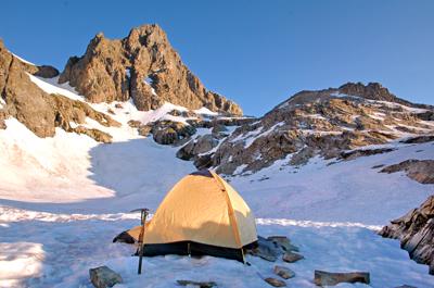
Most climbers use the shores of Ediza Lake as their High Camp for climbing in the Ritter Range. But we choose to go higher and set up camp on a high alpine snow field. We found this to be a good option because it gave us a nice high start for our Summit attempt. We also had no problem finding water in a large depression that had collected runoff from the melting snow and ice not too far from where we camped.

If you decide to backpack or fish in this section of the Sierra, you will certainly not be disappointed. The meadows, rivers, lakes, streams, and alpine scenery are nothing short of spectacular!
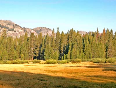
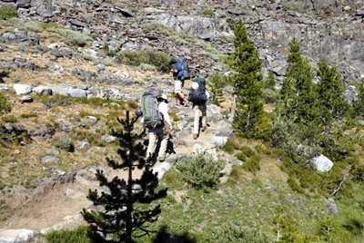
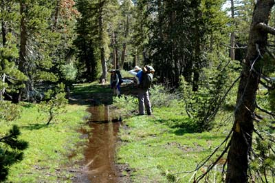
Once you leave the Trailhead on the Shadow Lake / River Trail, you will find yourself traveling down a fairly level path that skirts the edge of Agnew Meadows (shown in the image to the right above ). The going is nice and easy in the beginning, and the pine trees give you plenty of shade in this section. On our return from Thousand Island Lake we saw plenty of people enjoying this section of the trail. This including a lot of little folks possibly getting their first introduction into back country travel.
 After this initial (near level) section of trail the path turns downward and you loose a few hundred feet of elevation as you descend into a canyon. It is always a nice break to travel downhill for a bit.
But I would just as well have the trail go level or uphill when climbing a mountain. For as we all know, that downhill section has to be made up for later on.
Additional uphill sections will be encountered, and you never gain as much energy on the downhill as you loose when having to go back up. Sean, Ben, and Garrett are shown negotiating the downward section of the trail in the image to the left above .
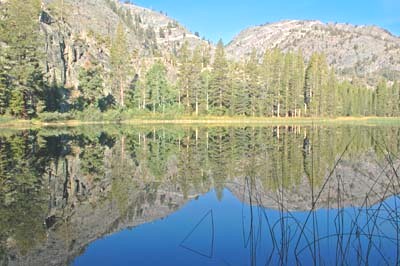
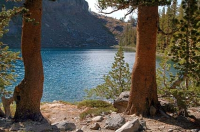
 When you reach the bottom of the canyon the trail becomes level again and you soon pass by Olaine Lake (shown in the photo to the right above ). We used this flat area in an earlier trip to camp out for the night because our permit required entry on the day we arrived. We got to the trailhead late at night, and we were forced to hike in a couple of miles to make our permit legal. The bottom of the canyon had ample flat areas for setting up up a quick camp site. If you decide on an option (such as described above) make sure your headlamp is on hand for the nighttime hike and you have fresh batteries.
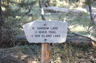 Toward the end of the canyon, you will come across a trail marker (as shown to the left). The River Trail pointing to the right is the quickest way to reach Thousand Island Lake.
 The Shadow Lake Trail takes you to Shadow Lake (obviously), but it is also the path you will want to take if you are heading for Lake Ediza. It is the most direct route to Climbing Mount Ritter, Banner Peak, or the Minarets. You can also reach Garnet Lake, Ruby Lake, Emerald Lake, and even Thousand Island Lake by taking the Shadow Lake Trail option.
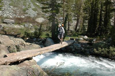
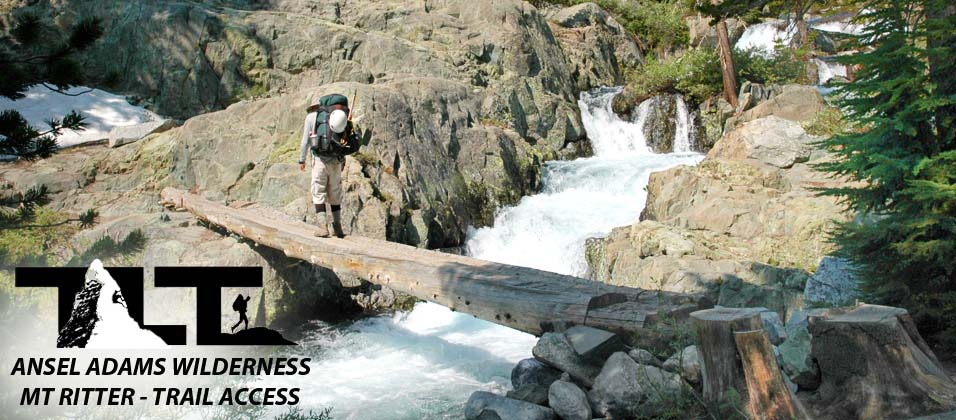
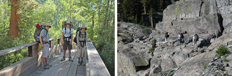 To do this, you will branch off to the north when you come to the John Muir Trail junction. I believe this is the more scenic route by far to Thousand Island Lake, but it is also a longer and more difficult route to the aforementioned lake. So if you are in a hurry, or want the easiest route to Thousand Island Lake, take the River Trail. It is the most direct route to the lake. If you choose the Shadow Lake fork, you will find yourself passing over a cool bridge that spans Shadow Lake Creek (see above left hand image). The bridge is within a very short distance from the trail marker.
On both our climb up Mt Ritter, and also on our August 25, 2007 backpack trip (where we made a loop by going up the Shadow Lake Trail, and then exited the area via the River Trail), we crossed the bridge (as shown in the left hand image above) and then hiked up a rocky section of trail. This part of the trail is shown in the above right hand photograph. In the photo below, you can see Mike rounding the corner with Shadow Lake Creek roaring down the canyon just below his position.
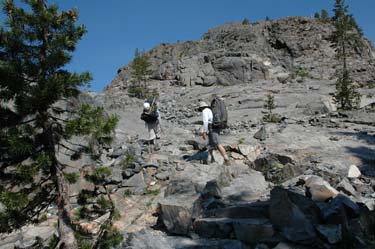 Once on top of the lip of Shadow Creek Canyon, the trail continues to push upward as you can see in the photograph to the right. above.
 In the left hand photo Sean, Mike, and Eddie look off in the distance at Mammoth Mountain. Hugely popular in the winter with snowboarders and skiers. The downhill slopes of Mammoth Mountain are mainly used by mountain bikers in the summer months.
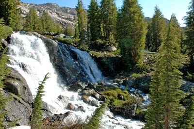
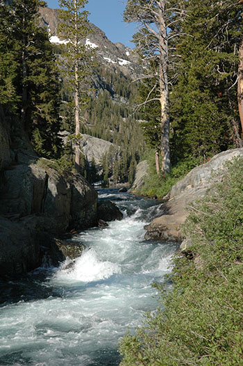 As you climb up the canyon as shown in the photograph above, you get a great view of the roaring creek bed as shown in the image to the right. Water is a very powerful force and you are advised to stay away from slippery river banks. Falling into a torrent of rapid moving water could very likely be fatal.
If you have to cross a stream or river, it is best to select the shallowest area where the water is not moving at a rapid pace. Fast moving water is very powerful due to the fact that it weighs 62.4 pounds per cubic foot and the force increases with the square of its velocity. To put this into perspective, lets say that the water is putting For example, water moving at just 4 miles per hour (a brisk walk) exerts a force of 66 pounds on each square foot (more than enough to take you off your feet). If the speed doubles to 8 miles per hour, it exerts a force of 264 pounds per square foot, or 4X the 66 pounds of the 4 miles per hour force. So the water crossing needs to be shallow and slow moving to be safe. I have seen torrents moving at 25mph and more, and at this speed, the water has the same pressure as wind moving at 790mph. Faster than the speed of sound. So all this being said, extreme caution must be exercised during any water crossings.
 I have great respect for fast moving streams and rivers and I certainly know of their great power. Every year is seems that people die from falling into fast moving water, but nevertheless, they provide for great scenic beauty and wonderful photo opportunities. The above cascading river photo was taken in mid July, but we found Shadow Lake Creek still running in good form in late August during the dry year of 2007. When most of the Sierra Nevada is fairly dried out by late August, the Ansel Adams Wilderness still has a very decent water flow. It receives a good amount of snow every year and this keeps the region green and beautiful.
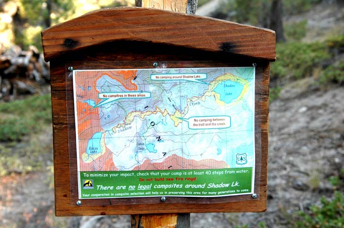
The sign in the above photo is displayed near the Shadow Lake outlet. It informs visitors of camping regulations in the area. In this case, it lets you know that there is no camping around Shadow Lake.
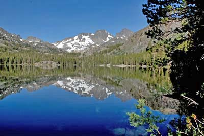
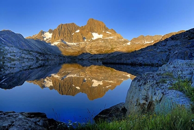
 After the second upward rise in the trail (after the canyon section), Shadow Lake is finally encountered. The left hand photo shows Mt Ritter and Banner Peak beautifully reflected in peaceful Shadow Lake.
If you like to fish, or are out for a leisurely backpack then shadow lake would be a great place to camp. Just make sure to follow the regulation and stay at least 100 feet from the lake or any water source for that matter while in the wilderness.
 The trail then skirts along the lake, and then reaches another major point where it intersects the John Muir Trail. The bridge shown in the photo to the right above (where Ben, Garratt, and Sean are standing), is in the southern direction of the John Muir Trail. We just walked across the bridge for a photo opp, but we went to the north (on the John Muir Trail) to Garnet Lake and Thousand Island Lake on August 25, 2007. But on our Mt Ritter climb, we crossed over the John Muir Trail, and picked up the Ediza Lake Trail in mid July of 2006. The below section first shows the terrain along the Ediza Lake Trail, and then further down the page, we switch over to the northern part of the John Muir Trail and show some of the spectacular scenery of that section of the Ansel Adams Wilderness.
 Beautiful meadows with lots of greenery delight the senses and provide a very refreshing location for rest stops, or a place to enjoy a quick snack or two.
Most of the time we get so busy scurrying up the trail (in order to get to our destination) that we don't take the time out to enjoy our surroundings.
That's why its nice to take photos while we are out there. The images allow us to review the beauty of it all when we are in a less hurried mind set.
During our visit to the area, we encountered lots of moisture on the mountain. The trail in the upper left hand image shows the grassy meadow portion of the trek.
It was still under water in mid July. Waterproofing your boots is a must so that you can keep your feet dry. This avoids all sorts of problems such as blisters and other types of ailments that come with wet feet.
 Note Mount Ritter in the background in the image to the left above and the beauty of the pinkish red wildflowers in the foreground. Its views like this that make all the hard work and effort worthwhile.
 Mountain terrain can be a very fragile environment. Some people get upset about back country rules, but I appreciate those who take responsibility for keeping the wilderness from being trampled by droves of people. It preserves it for future generations to enjoy. Because the growing season is short at high altitude, delicate wild flowers can take years to develop and only a moment to destroy. It is always important to consider this fact when traveling cross country.
Leave no trace is a great policy when it comes to wilderness travel. There is a certain reward all its own when you can leave an area in a condition that appears to be untouched by any human visitor. It preserves the wilderness experience for future travelers.
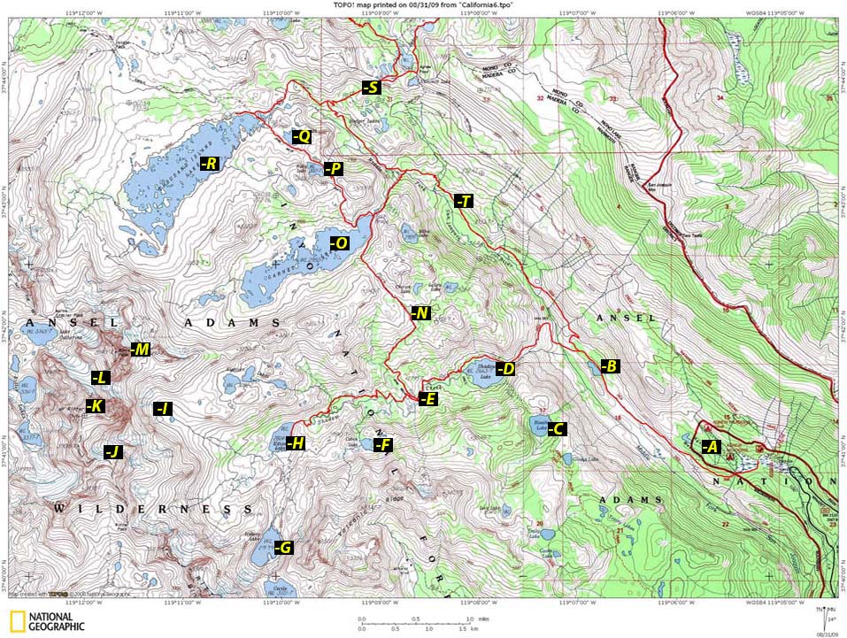 AboveTopo Map
used with permission from National Geographic
AboveTopo Map
used with permission from National Geographic- Agnew Meadows Trailhead
- Olaine Lake along the first leg of the Shadow Lake Trail
- Rosalie Lake
- Shadow Lake
- Junction of Shadow Lake with John Muir Trail. Head toward Ediza Lake "H" for the best position to climb Ritter and Banner Peak.
- Cabin Lake
- Iceberg Lake
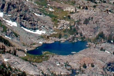
- Ediza Lake (Beautiful lake and wonderful surrounding scenery, including the Minarets. Used as a base camp for many climbers).
- This is where we camped when we climbed Mt Ritter's North Face Route. Also excellent position for climbing the Southeast Glacier or Banner Peak.
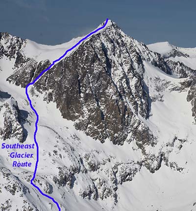
- Southeast Glacier Route on Mt Ritter.
- Summit of Mt Ritter
- Ritter / Banner Saddle
- Summit of Banner Peak
- John Muir Trail. This is the route you would take to do a beautiful loop trip from Agnew Meadows, or for packing north toward Yosemite.
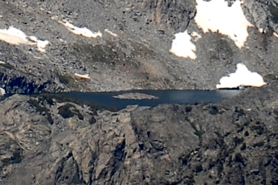
- Garnet Lake (Very popular lake for photographers and fisherman. Very Scenic)
- Ruby Lake
- Emerald Lake
- Thousand Island Lake (Extremely popular destination for backpackers, fishermen, photographers, etc. Very Scenic Location).
- Continuation of the John Muir Trail heading north.
- River Trail. (Use the river trail if you want to get to Thousand Island Lake with the least amount of mileage from Agnew Meadows, or use for a loop trip).
 Mike (above left) examines what we called the "Elephant Tree." We saw several of these structures not too far from Ediza Lake. We were not sure what caused this phenomenon, but the trees were curious sights to say the least. Eddie (in the above photo to the right), negotiates a great log crossing. Trail builders went to some work here shaping this natural bridge. A big thanks to the people who build these trails. Without the help of this bridge crossing, we would have to spend a bunch of time and risk to get around this fast moving stream. Still, there is no railing here, so you do not want to stumble. Falling into the rushing water below would be extremely unpleasant to say the least and possibly fatal at the worst.
 The trail turns upward (as seen in the photo to the right above ) once again before reaching beautiful Ediza Lake. The winter of 2005-2006 had a fair amount of snow, and we ended up having to kick in some steps to keep from slipping. The bridge marks the intersection of the John Muir Trail and the Ediza Lake Trail.
The John Muir Trails northern entrance begins at Happy Isles in Yosemite Valley and ends at the Summit of Mount Whitney. The footpath spans 210.4 miles in total. The trail resides entirely in the High Sierra backcountry and wilderness areas. The John Muir Trail is also a part of the larger Pacific Crest Trail. Mt Ritter along with many other Peaks and wilderness areas are named after John Muir, and if you spend any time at all in the Sierra hiking or backpacking, you will see signs that state "You are entering the John Muir Wilderness" The trail is world renowned for its beauty when it comes to high mountain scenery. Most of the pathway travels at or above 8,000 feet in elevation, and during the last 30 miles you will have the privileged of hiking above 10,000 feet as you complete the final leg to the top of Mt Whitney which tops out at 14,505 feet above sea level.
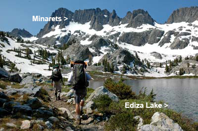
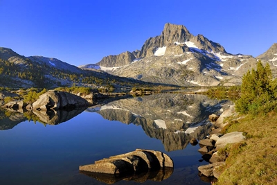
 Once at Ediza Lake, (images left and right) the Minarets come into full view. They make for spectacular mountain scenery in this rugged landscape. Ansel Adams Wilderness is truly a remarkable place to visit. John Muir considered this area to be one of the most beautiful places in all the Sierra Nevada. The trail runs along the southern portion of Ediza Lake, and then the trail ends. However, as beautiful as Ediza Lake was, we did not camp there. We wanted to get a higher start for the next days climb, so we went up to an upper snowfield and set up camp there for our morning climb. Our campsite is featured in the High Camp section of this trip report. After Ediza Lake, you must switch to cross country travel for the rest of your approach to Mt Ritter and/or Banner Peak. As mentioned above, the trail ends at Ediza Lake.
") You get great views of Ritter and Banner from Ediza Lake. Many climbers use the lake for their base camp for climbs in the Ritter Range. It is certainly a beautiful place to set up camp and with the lake you will have no problem getting water.
You get great views of Ritter and Banner from Ediza Lake. Many climbers use the lake for their base camp for climbs in the Ritter Range. It is certainly a beautiful place to set up camp and with the lake you will have no problem getting water.Note: Be sure to filter your cooking and drinking water. Ansel Adams Wilderness is very well traveled and the human element, unfortunately, is present in the lakes a streams in all the popular areas in the Sierra Nevada. For much more on the subject of water and purifying it please see our page on Water/Dehydration.
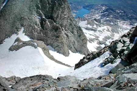
As mentioned above, we choose to go up higher for our base camp. The image to the left above shows both Mt Ritter and Banner Peak in the background. We found ourselves having to cross several small water tributaries (some of which we found a bit troublesome), before we hit better ground above the Lake.
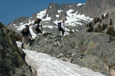
 Sean is shown crossing a large snowfield (image above right) near our high camp on Mount Ritter. Once in this amount of snow I usually put on my crampons. Even though you can negotiate this angle of snow easily without them, I find that they just make travel a little faster. Then in the photo above left, you will see a bridge crossing taking the hiker south on the John Muir Trail to Ediza Lake and the climbing high camps for Ritter and Banner.
Not far from this point we reached our High Camp for our Mt Ritter climb. We will now backtrack to where we met up with the John Muir Trail (letter "E" on the map above), and explore the northern portion of this famous trail (letter "N" on the map above) as it passes through the Ansel Adams Wilderness. So, if you are planning on climbing Mt Ritter or Banner Peak, then continue up the slope as Sean is doing in the right hand photo, and go onto high camp (letter "I" on the map above) for your climb. If you are more interested in a beautiful loop, then continue down the page to explore this option (letter "N" on the map above).
 If you want to make the Ansel Adams Wilderness Loop toward Garnet Lake and Thousand Island Lake, then you do not cross the river, but go North on the John Muir Trail as shown in the photo to the right. above.
This will take you past the Lakes as mentioned and you will eventually meet up with the River Trail in the Thousand Island Lake area, that will return you to the Agnew Meadows Trailhead where we began our adventure.
So, if you are a backpacker or hiker, you may want to take a side trip up to beautiful Ediza Lake and cross the plank bridge as shown above, and then backtrack down and go north to Garnet Lake and Thousand Island Lake. Or, you may want to just skip Ediza Lake all together and go for the loop right away and head for the returning River Trail option at the Thousand Island Lake area.
Either way, you can't go wrong, because there is so much to see no matter what option you take.
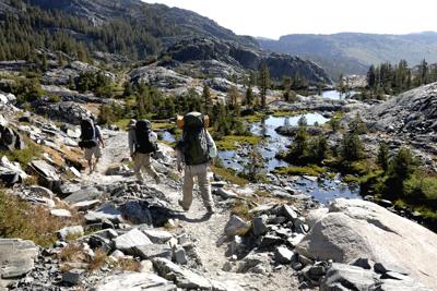
 Getting to Garnet Lake from the intersection of the Shadow Lake Trail, and the John Muir Trail going north, is a mostly uphill project. Only toward the very end just before reaching the lake, does the trail turn downward.
We found the section of trail that goes north from the intersection of Shadow Lake Trail and the John Muir Trail (to Garnet Lake), to be the most difficult portion of the loop. From Garnet Lake to Thousand Island Lake is fairly easy. At Thousand Island Lake, you meet up with the River Trail. The River Trail (marked "T" on the above map) will then take you back to Agnew Meadows to complete your loop.
Note: You also could reverse all the above by taking the River Trail to Thousand Island Lake, Garnet Lake, and then back down on the Shadow Lake Trail, but I recommend the Shadow Lake Trail to River Trail option, because you get all the hard work over with early on.
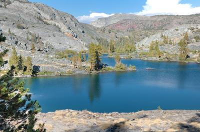
 But all that hard work pays off, when you reach Garnet Lake. Note the beautiful natural lighting in the image to the left above as it displays the early morning light reflecting Mt Ritter and Banner Peak in Garnet Lake.
We camped near the banks of Garnet Lake for the night, and were greeted with this spectacular scene in the morning.
As mentioned before, the Ansel Adams Wilderness area is very hard to beat when it comes to premium backpacking, hiking, and photography oportunities in the Sierra Nevada.
 The upper right hand photo was taken using a flash in order to light up Russ fishing in the shadows. But using the flash completely changed the overall camera exposure, and the altered camera settings negatively impacted the beauty of Mt Ritter and Banner Peak. Needless to say, the way you use your camera has a profound effect on your end results.
 Next comes crystal clear Ruby Lake. Most people hang around Shadow Lake, Ediza Lake, or Thousand Island Lake, and do not visit Ruby Lake (photo above right) or Emerald Lake (shown in the below left hand image). But if you want to get in some great fishing on a remote lake, Ruby and Emerald Lake just may be your ticket. They are truly a couple of jewels in the Ansel Adams Wilderness.
 Emerald Lake as seen in the photograph (above left) is composed of crystal clear blue waters that make it so inviting to all who visit its shores. Above right, you see a trail marker identifying the J.M.T (John Muir Trail), the way to Shadow Lake Trail, the P.C.T. (Pacific Crest Trail) junction, and the Reds Meadow cut off. The Ansel Adams Wilderness is so spectacular, that all of these world class trails make sure to route their way through this region. The sign also reminds campers that there can be no campfires above 10,000 feet. This is a common regulation in the Sierra Nevada.
 Finally at the height of our backpacking loop, we reached Thousand Island Lake. We had planned all along to camp at this fantastically beautiful lake, and we were certainly not disappointed with our choice. There are a multitude of campsites in the area (but there are some restrictions). Common to all wilderness areas in the Sierra Nevada, you cannot camp within 100 feet of the lake shores. This regulation is true for all waterways in the Sierra Wilderness.
Even though you cannot see the Minarets from this vantage point (due to Banner Peak blocking the view), it beauty reflected in the lakes more than makes up for it with its looming presence above the islands. As mentioned in other areas of Timberline Trails, Thousand Island Lake is a photographers and fisherman's paradise, and during the summer months the lakes shores are full of visitors enjoying the area.
 When setting up camp in the Thousand Island Lake area, or any area for that matter in the Ansel Adams Wilderness, make sure you place all your scented items in your bear canister. Bears frequent the area and most likely you will have a bear visit you in the night. We did. And the bear did a pretty complete search through our packs and other items that we left outside the tent. Needless to say, if we would have left any food or scented items in our packs, they would have been ripped to shreds.
 Bear canisters are not only critical to keep bears out of your stuff, but they also come in handy for keeping other critters at bay. Marmots can be relentless when it comes to getting food, and can do there fair share of damage to packs and tents if you leave food unattended. Properly store all your food, lip balm, sunscreen, and the like in your bear box (needless to say, never put any of these items in your tent during the day or night).
 In the morning, we had our breakfast, and headed down the River Trail toward Agnew Meadows. The scene to the right above shows the beginning of the River Trail, and it is beautiful indeed.
 You will follow the river (thus the name River Trail) pretty much all the way down the mountain. But in several areas, you will veer away from the river a bit, but then return back to it later on.
The most beautiful part of the River Trail is just before you reach Thousand Islands Lake going up, and just after leaving going down.
Other than the Thousand Island Lake section, the River Trail is not quite as scenic as the Shadow Lake / John Muir Trail option. But for a quick easy route back to the trailhead (or to Thousand Island Lake to begin with), it is hard to beat.
 We found the trail wonderfully shady and much more gradual (in terms of elevation gain) then the Shadow Lake Trail. It is also the best trail option to take from Agnew Meadows if you want to reach Thousand Island Lake or Garnet Lake in the quickest manner possible, and the sandy composition of the trail makes travel easy on the feet for an additional bonus.
Well that's about it for our experience on the trails in the Ansel Adams Wilderness. There is so much to this area, that we have hardly scratched the surface. One could spend his or her entire life exploring this region. It is so vast and beautiful that one would never become bored.
The lakes are like paradise for the fisherman, the peaks provide the mountaineer with all sorts of challenges, and the photographic opportunities are endless. All this is why I would consider the Ansel Adams Wilderness about as good as it gets when it comes to hiking, backpacking, and mountaineering.
 For more on this beautiful Ansel Adams Wilderness area please click in the Mt Ritter Menu for more adventure.
Email Sign Up

| Join the Adventure! Sign up here for Timberline Trails Monthly Newsletter |

Join us on Instagram
©2006-2022 TimberlineTrails. All Rights Reserved.