 The Sierra Nevada - is located in the USA in the state of California. The range contains some of the most beautiful landscapes to be found anywhere in the world. The terrain is so varied that one may start out in desert conditions and end up with the sound of crunching ice under foot and the ring of a distant ice ax in a remote frozen gully well above timberline. The Sierra Nevada extends 400 miles from north to south starting at the shore of Lake Almanor in the north to Tehacahapi Pass, just south of Bakersfield. The range varies from 60 to 80 miles in width. With 13 peaks that exceed 14,000 feet, and 500 peaks that exceed 12,000 feet there is an incredible amount of alpine territory to explore.
For the fisherman the Sierra Nevada is a playground of lakes, streams, and rivers that will delight the most zealous of anglers. For the hiker and or backpacker, the mountains have a system of trails and camps that are unrivaled anywhere else in the world. Cross country skiers will find outstanding snow conditions during most of the winter, near perfect corn snow during the spring months.
If you are a climber or mountaineer there are more than enough rock walls, high angle gullies, ridges, peaks and summits to last a life time.
Keep a camera handy on all your trips, because the lighting conditions and scenes are so beautiful that you will be constantly reaching for it. Add to this the fantastic California mountain weather, and no wonder folks from all over the globe travel huge distances just to visit this "Range of Light"
Weather - Temperatures / Precipitation / Snowfall
Sierra Temperatures are generally warm in summer with a maximum ranging from 80-100 degrees F. and a minimum of 15-37 degrees at higher elevations. In the winter, maximums are typically 55-70 during the high point of the day, and between 0 to -32 degrees F. in the night. In general, temperatures decrease 3-5 degrees for every 1000 feet of elevation gain.In the Sierra Nevada, 95 percent of the precipitation falls between October and May,with more than half falling in January through March. But there is a great discrepancyin the amount of rainfall between the western slopes and the eastern slopes.
The west receives 75 inches while the eastern slopes receive only 20 inches on average. The reason for this discrepancy, is because of the so called "Sierra Rain Shadow." The sheer height of the imposing wall of peaks reaching heights of over 14,000 feet, exert an incredible influence over the amount of precipitation that the Eastern Sierra receive each year. This influence continues to make it self felt, and is the reason why, thousands of feet below, we have the extensive and arid "Great Basin" that extends clear into Utah and Nevada.
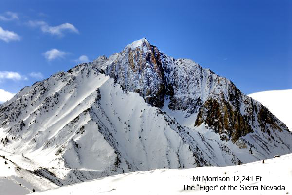 The exception to all this, is the Mammoth Lakes area of the Sierra, which Mt Morrison (photo to the left) (photo above) is a part of. Mammoth Pass, which is a low point in the crest, allows for the moist air of Pacific storms to funnel through to the east side. This break in the crest, makes the Mammoth area the wettest part of the Eastern Sierra. Mammoth Mountain Ski area receives an average of 342 inches of snow annually making it the premier winter sports destination for the multitudes who live within a days drive to reach its slopes. During the summer months, the only moisture that the Sierra gets is from the now and then afternoon thunderstorm. They are short lived, but this does not mean that you do not have to prepare for them. Temperatures can fall to dangerous levels at any time during the year, and this is especially true at higher elevations. Getting wet in the mountains can be deadly, and Hypothermia can quickly set in if you are not prepared. Normally dry conditions on the eastern side of the Sierra can give people a false sense of security, and I have run across backpackers and climbers who make it a habit to go into the back country and not carry any rain protection (such as a tent and rain fly for overnight camping).
 But even though 70 percent of all days during the months of July and August are sunny, there is still that 30 percent chance that there will be some sort of rainfall.
I remember meeting one back country traveler in the morning after a previous night of heavy rainfall while climbing Mt Williamson. He told me that he never carried night time rain gear for years, but this time he got caught. He said it was an exercise in torture having to endure unusually cold night time summer temperatures while being soaked to the bone. He said that he talked himself into surviving five minutes at a time until morning. We always bring rain gear for the night no matter what time of year, and the above story should encourage us all to do so in the future.
But even though 70 percent of all days during the months of July and August are sunny, there is still that 30 percent chance that there will be some sort of rainfall.
I remember meeting one back country traveler in the morning after a previous night of heavy rainfall while climbing Mt Williamson. He told me that he never carried night time rain gear for years, but this time he got caught. He said it was an exercise in torture having to endure unusually cold night time summer temperatures while being soaked to the bone. He said that he talked himself into surviving five minutes at a time until morning. We always bring rain gear for the night no matter what time of year, and the above story should encourage us all to do so in the future. Snowfall is one of the most wonderful features of the Sierra. Being the second snowiest mountain range on the continent, (only exceeded by the Pacific Northwest Cascades) brings with it plenty of snow pack during the winter months.
It is difficult to put a number on how much snow falls in the Sierra, however, because it can vary greatly. For instance at Tamarack, Alpine county only 13 feet of snow fell in 1880-1881 and 73.5 feet fell in the winter of 1906-1907.
Check out the below links for a "Current Weather Report" in some of the popular areas in the Sierra's:
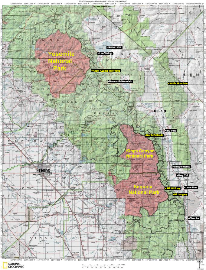
Mt Whitney Ansel Adams Wilderness Yosemite National Park
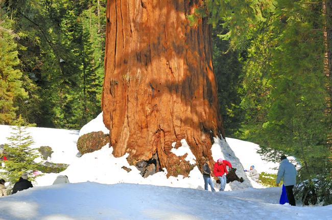
 Sierra Nevada is Spanish for "Snowy Mountain" and is made up of a massive block of granite, called a batholith. Heavy snow falls during most winters, and there are many permanent snow patches and several small glaciers. The Sierra Nevada has earned the name "Snowy Mountian" because it is the second snowiest mountain range on the North American Continent. There is such heavy snowfall during the winter and spring months that the resulting snowpack is equaled only in the Pacific Northwest.
Most of the early inhabitants to the range were Native Americans who wintered on its lower flanks, and foraged in its higher elevations during the summer. But the discovery of gold in the western foothills changed all that. What was known as the "Mother Lode" brought an amazing invasion of speculators and miners from everywhere imaginable. During this time, and well after, timber production and livestock grazing also became excellent commercial enterprises.
In 1851 tales of Yosemite Valley along with the Giant Sequoia were being told by white settlers and the possibility of using the Sierra Nevada as a place of recreation and refreshment started to take shape. The building of a railroad across the range and a connecting narrow-gaugh line from Truckee to Lake Tahoe (1685 feet deep) led to the establishment of early resorts and summer homes in the area.
Today, the Sierra Nevada is considered by most as a national treasure. With its rugged terrain, varied resources, beautiful flora and fauna, and countless recreational opportunities for the casual visitor to the most committed mountaineer, the Sierra has something to offer everyone.
Below are some examples of just a few of the outdoor activities that you can enjoy in the Sierra Nevada. But for a quick photographic overview of the Range, Click Here. It is a quick way to see some of the beauty that these magnificent mountains have to offer.
 Backpacking and Hiking in the Sierra
As mentioned above, the Sierra Nevada has a trail system second to none, and opportunities for Hiking and Backpacking abound. The term High Sierra applies to the alpine region above the main forest (8,000 ft +). The photo to the left above is a perfect example of this. Peaks, lake basins, beautiful rock structures such as Temple Craig shown in the background of the right hand image were carved by glaciation during years past.
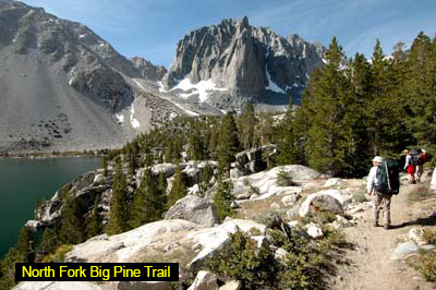
Notice the green tint of Third Lake visible in the left hand portion of the photo to the left. above. This coloration is due to the fact that it is fed by glaciers up above. The grinding of hard rock produces a green silt that gives the water its color. Here you see hikers/backpackers negotiating the North Fork of Big Pine Creek trail. For more about this particular trail, check out this link: North Fork of Big Pine Creek.
 In the heart of the Sierra Nevada, there is a section that extends about 150 miles from north of Yosemite to Cottonwood Pass. This area averages about 20 miles in width between the peaks, and there are extensive highlands that are relatively flat and open. This is the land of the hiker and backpacker, accessible only in summer by most, and by only the hardiest of individuals during the winter.
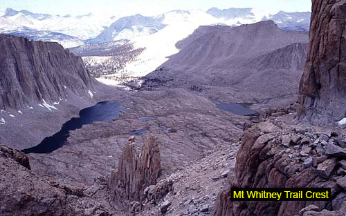
 To the left, Above, you are looking down into Sequoia National Park from a vantage point known as Trail Crest situated at an elevation of 13,700 feet. The lookout point at Trail Crest, is arguably one of the best views you will encounter during your entire hike along the Mt Whitney Trail. The shores of the lakes below as seen in the photo are only accessible to committed hikers, backpackers, and pack trains. The large flat expanse below is a perfect example of the extensive highlands described above.
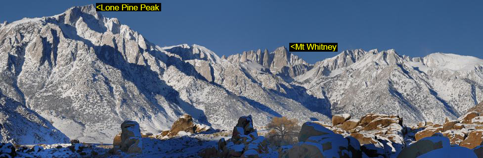 Another incredibly popular trail in the Sierra is the Mount Whitney Trail. In the above panorama, you can see Mt Whitney in the background, with Lone Pine Peak dominating the foreground in the upper left hand portion of the photo. Below right, you see hikers working their way up the trail. On the lower part of the above mentioned trail. The pathway is graced with beautiful lakes, stone walkways and meandering steams. They provide delightful camping areas for overnight stays.
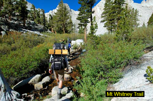 For many folks, a hike to the top of Mt Whitney is on their lifetime list of things to do. Having ascended the peak six times, I would have to say that it is a tremendous experience and one that I would highly recommend. Mt Whitney is the highest peak in the lower 48 and has one of the best maintained trails in all the Sierra Nevada. The trail is a well maintained 11 mile foot path to the summit of Mt Whitney. The trail begins at 8,360 Ft, and ends at the 14,505 Ft summit of Mt Whitney. This places the total elevation gain at 6,137 Ft. I would rate Mt Whitney as the third easiest of the fifteen California peaks (that soar above fourteen thousand feet) behind White Mountain and Mount Langley. But Mt Whitney (due to it being the tallest peak in the continental United States) receives the heaviest traffic by far of all the peaks in the Sierra Nevada.
The below links will take you on a journey to the summit of Mt Whitney.
Base Camp Getting Started Trailhead Trail Guide High Camp Trail Crest Summit East Face Route Aerial Photos Current Weather Mt Whitney Video Trail Slideshow Aerial Slideshow
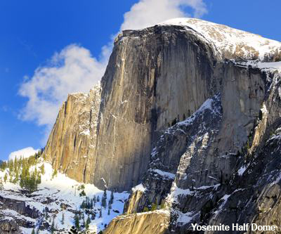 Yosemite National Park - is also part of the Sierra Nevada Range. I found Yosemite to contain some of the finest hiking in all the range. Taking the time to hike the spectacular Mist Trail is enough reason in and of itself to take a trip to Yosemite. The Mist Trail is Yosemite's most popular trail by far, and people come from all around the globe to enjoy all that it has to offer. For the more adventurous, there is the Half Dome Cable Ladder. It allows the non-climber to access the summit of Half Dome (seen in the left hand image) (seen in the image above) where the views are nothing short of inspiring. Early on in my marriage, my wife and I hiked nearly every trail out of the valley floor and found the experience of hiking Yosemite very rewarding.
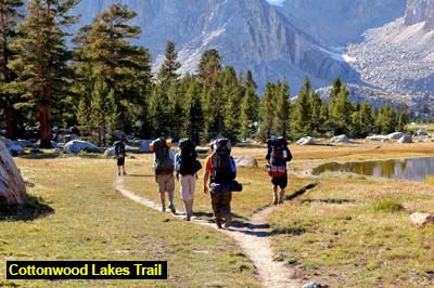 The Cottonwood Lakes Trail - on the southern end of the High Sierra offers a very high start at 10,000 feet, and provides a gentle rise to the beautiful Cottonwood Lakes basin. I found this trail to be extremely enjoyable. It also provides opportunities for the fisherman to test his or her fishing skills. We most often use this trail to climb Mt Langley, but it also leads to many other back country adventures.
 For more info on the Cottonwood Lakes Trail check out the following links:
Mt Langley Getting Started Trailhead Cottonwood Lakes Trail High Camp Summit
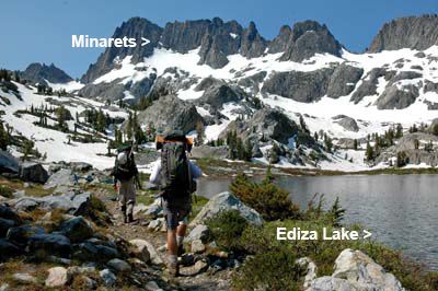 The Ansel Adams Wilderness - is about the finest hiking/backpacking areas in the whole Sierra. The Shadow Lake Trail is a fantastically beautiful path that criss crosses the Ansel Adams Wilderness. John Muir found this section of the Sierra to be his all time favorite. And it is of little wonder. The trail skits some of the most beautiful lakes, waterfalls, and meadows anywhere to be found in the range. The area is graced with heavy snows during the fall, winter, and spring and this assures a provision of plenty of snow to feed pristine glaciated slopes that will later in season be used to bring waterfalls, lakes, and streams to full capacity. The wildflowers (in season) and greenery found on the lower sections of the trail will delight your senses. Shown to the right, you see backpackers skirting picturesque Ediza Lake with the jagged Minarets in the background.
 To the left Above you see a photo of Banner Peak reflected in one of the lakes in the Thousand Islands Lake District. This is a one of the all time favorite sites for fishermen, photographers, and backpackers. If you decide visit this area, make sure to follow the rules and carry a bear canister to store your scented items. During most of the year, it is almost a guarantee that you will be visited by a bear. Every time we have backpacked in the Thousand Islands Lake District, there were bears in the area.
For more on Mt Ritter and the Ansel Adams Wilderness, check out the below links:
Base Camp Getting Started Trailhead Shadow Lake Trail High Camp The Climb Shadow Lake Trail High Camp The Climb Summit Aerial View Ritter Weather
 Sequoia/Kings Canyon National Parks - also provide the back country traveler with multitudes of opportunities for hiking and backpacking. The scene to the right is what you will see if you hike the gentle Giant Forest Trail.
 This trail is so accessible and mild that you will want to take your little ones with you.If you have not seen the Giant Sequoias (photo to the right) you are in for an incredible treat.
The shear scale of these trees (the largest on earth) is nothing short of awe inspiring and there is a whole forest of them available on this special little trail. Just get a map from the ranger as you enter the park, and drive to Giant Forest. The trail begins right out of the parking lot area. SIERRA NEVADA MOUNTAIN CLIMBING OPPORTUNITIES - in the Sierra Nevada is like none other in the world. The shear scale, the fine granite rock, the magnificent lighting, along with varied terrain and mild weather (in comparison to other mountain ranges on earth), make the Sierra Nevada a mecca for mountaineers and climbers. After climbing in the Sierra Nevada for years, I can say with confidence that these mountains have something to offer climbers of all ages and abilities. From easy scrambles to heart stopping sheer walls of smooth granite and vertical ice. No climber will come away disappointed. Yosemite offers the rock gymnast climbing opportunities that are the envy of the world. If you are in to more remote and mixed climbing that offers glacier travel, snow and ice climbing, and rock walls to boot, try the most alpine region in all the Sierra Nevada, the Palisade Crest.
The Sierra Nevada offers so much for the mountaineer/climber, it would be impossible for us to describe even a small fraction of all the opportunities for the above types of adventure. So we will just give a you a tour through what I believe to be some of the finest alpine terrain in all the range.
So to start with, we will give you a tour through some of the fine alpine climbing opportunities in the Palisade Region of the Sierra.
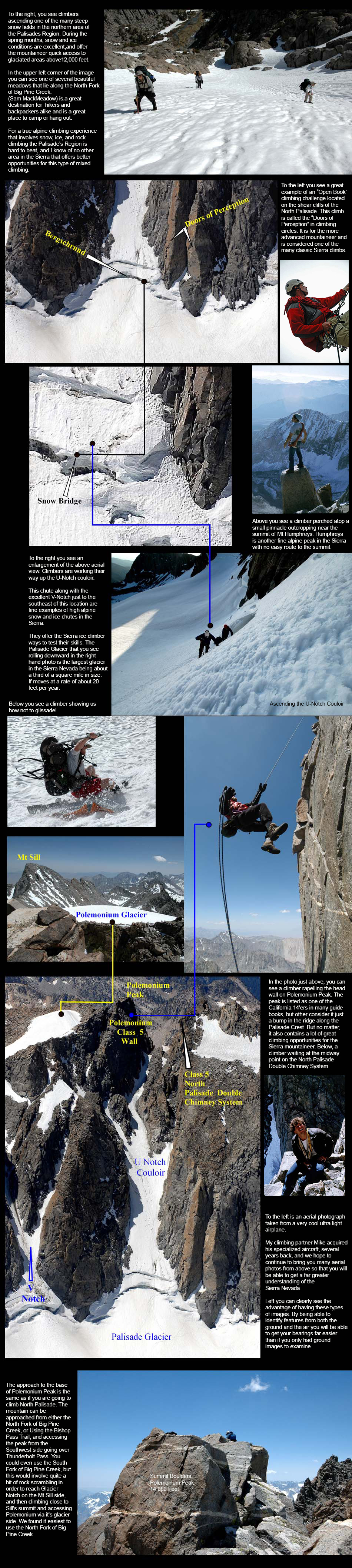 For more on the North Palisade, please check out the following links:
 Base Camp Getting Started Trailhead The Approach High Camp The Climb Summit Aerial Photos
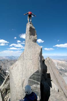 Starlight Peak - is one of the most spectacular summits in all the Sierra Nevada. Stephen F.Porcella and Cameron M. Burns, in their book "Climbing California's Fourteeners," describe Starlight Peak this way: "The summit is a single rock monolith standing over 30 feet high and tapering to a point only 2 feet wide. Upon reaching this diminutive point, the climber's senses are besieged by vertigo as well as euphoria. The ridge below, much like one's stomach, seems to drop out from beneath. More than 1,000 feet below to the east lies the magnificent Palisade Glacier. To the west lies the incredible expanse of Dusy and Palisade Basins. The view, like the exposure, is nothing short of exhilarating." To the right, Above, you see a climber standing on this very small piece of real estate known as the Starlight Peak Summit.
For more about this climb, please visit some of the below links:
Base Camp Getting Started Trailhead Trail Guide High Camp The Climb Summit Aerial Photos Well, that's just a very small example of some of the climbing/mountaineering opportunities in the Sierra Nevada. There are countless peaks, basins, ridges, aretes and rock walls for climbers of all abilities to test their skills. But before you begin any type of climbing activity please get proper training. See our Introduction to climbing, for more information.We also have a general Safety writeup, along with Backpacking Food, and a section on Climbing Knots and a writeup on Altitude Sickness. This area is still under construction and we hope to offer a whole lot more information for you in the future. As time permits we will add more details involving climbing in the Sierra Nevada. Having climbed for over 30 years off and on, it will take a lifetime to get the thousands of slides, digital images, and stories together. So we will never run out of material for future presentations.
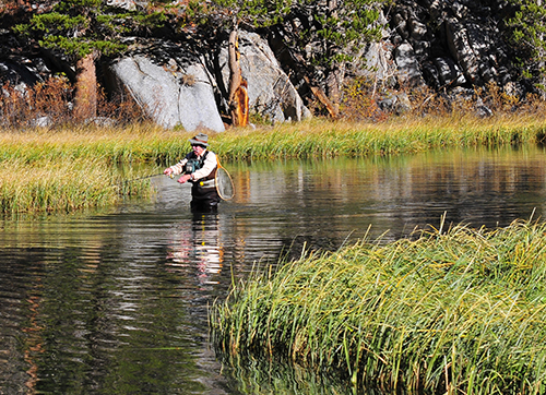 FISHING IN THE SIERRA NEVADA
There is no end to lakes, streams, and rivers for the Sierra fisherman to enjoy. In fact, there are more than 4,000 named lakes and 11,000 miles of streams in the high Sierra, most located on federal lands managed by the National Park Service and the U.S. Forest Service. Many of the high elevation lakes and streams did not originally have fish in them. But this was changed in the 1860s, when sportsmen's groups, the Sierra Club, the U.S. Army, the California Fish Commission and individual outdoorsmen introduced trout into fishless streams and lakes throughout the Sierra Nevada to increase recreational fishing opportunities
Though not a fisherman myself, I have certainly come across many an angler while exploring the back country waterways in the Sierra. I have to say there are far more fisherman out there than climbers, and after many a conversation with anglers, they tell me that I am missing out on one of the best activities that the Sierra Nevada has to offer.
 I hear the fishing is fantastic in these mountains. And I must confess that I do get a bit envious around dinner time when I think of how they must be enjoying their fresh catch while I chock down my freeze dried chili-mac dinner. Some of the guys that have joined me on some of my Sierra adventures are fisherman and they tell me that they are going to give me some pointers on the art of fishing. As I become a bit more knowledgeable in this area, I will certainly share it with you.
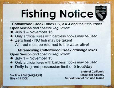
 To the right is the fishing regulation notice at the Cottonwood Lakes Trailhead. It leads up to the 7 lakes that makeup the upper meadow basin below Mt Langley. I also hear that the Shadow Lake Trail which goes to Thousand Islands Lake district has outstanding fishing opportunities. I have a couple of friends that go up there year after year to go fishing in this section of the Sierra Nevada. They never come back disappointed.
 OTHER ACTIVITIES:
Hiking, Mountaineering, and Fishing are not the only things to do in the Sierra. There are other areas of interest that Sierra travelers can enjoy.
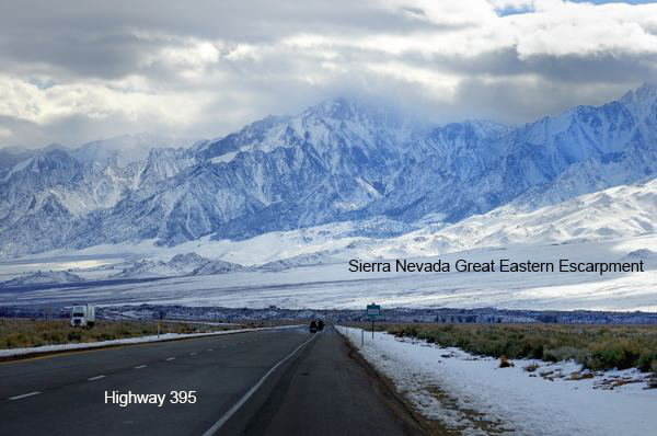
Just taking a ride along the massive eastern escarpment of the mighty Sierra Nevada Mountains on highway 395 in the winter (as shown in the photo to the right), is a wonder all on its own. I love being out and about during the winter months exploring along the base of the Sierra.
Also, the little towns along highway 395 have much to offer. They are part of the history of the Sierra Nevada, and no story on the Sierra is complete without considering all the wonderful activities that take place at the foothills of these world famous mountains. Above is just a small example of some of the things that you can do in these magnificent mountains. So at this point, we hope that you will use what you have learned here and then go out and create treasured memories of your own. One could spend a lifetime in the Sierra Nevada and still have only begun to scratch the surface of all that is out there. Hollywood and other film industries choose California as a location to do much of their filming, and for good reason. It is the lighting! There is just something magical about it. Is it any wonder that John Muir named this incredibly special mountain chain, "The Range of Light"
Email Sign Up

| Join the Adventure! Sign up here for Timberline Trails Monthly Newsletter |

Join us on Instagram
©2006-2022 TimberlineTrails. All Rights Reserved.