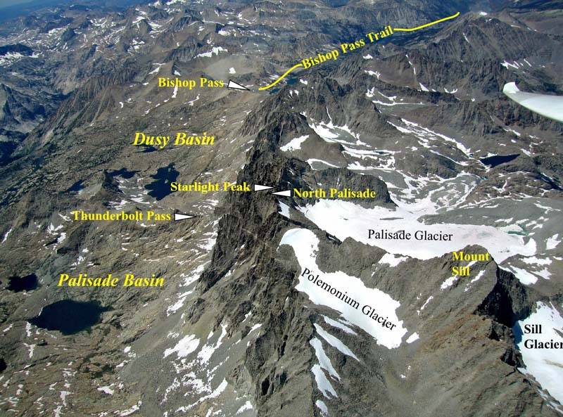

Starlight Peak - Aerial View of Palisade Crest and Surrounding Areas
This Aerial Photo of Starlight Peak - and the surrounding areas gives one a great view of the entire scope of the
Starlight Peak climb. The southwest approach to our featured peak starts with the Bishop Pass Trail. Once you reach Bishop
Pass, you leave the trail and travel cross country across Dusy Basin and head for Thunderbolt Pass. The scale is so huge that
you do not see the incredible amount of rock that you have to scramble through in order to reach Thunderbolt Pass (lots of
hard work). From there, the real climbing begins (as you can see from the very steep walls leading up to Starlight Peak from
Palisade Basin) as you enter the third chute from the pass, you encounter a combination of class 2, 3, and 4 climbing. All this
culminates with the 5.4 rated pinnacle that makes up the final summit block.
Bishop Pass Trail - Access Trail to climbing routes on the northwest side of the Palisade Crest. Fourteener's such as
Thunderbolt Peak, Starlight Peak, North Palisade, Polemonium Peak, and Mount Sill can all be accessed from this side of the
crest as well as the opposite side.
Bishop Pass - Point of entry into Sequoia National Park, and Dusy basin. (11,960 Ft)
Thunderbolt Pass - Most often serves as "High Camp" for climbers on northwest side of crest. (12,360 Ft)
Palisade Glacier - Largest Glacier in the Sierra Nevada Mountains
Photo by Mike Koerner
from his Sail Plane
from his Sail Plane
North Pal Links
Base Camp
Getting Started
Trailhead
The Approach
High Camp
The Climb
Summit
Aerial Photo
Aerial Photography
Home Page
Base Camp
Getting Started
Trailhead
The Approach
High Camp
The Climb
Summit
Aerial Photo
Aerial Photography
Home Page