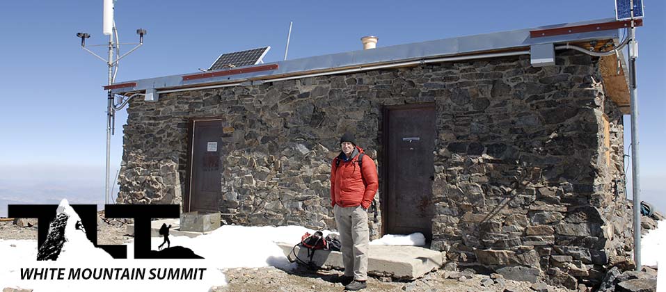
 Located on the Summit of White Mountain Peak - and
featured in the photo above, is a high altitude research station. The small lab being at 14,246 feet above sea level is the highest high-altitude laboratory in North America (and fourth highest in the world). As discussed in the Trail Guide section of this site, research continues to be conducted on a variety of disciplines, including archeology, physiology, biology, and aerospace. The complex is operated by the University of California. There is also a live weather station located on the summit, and you can get current temperatures and wind speeds by clicking here. Even though the summit lab is locked most of the time, experiments are being conducted and recorded on the instruments inside and out. This, along with other obvious reasons, is why they do not want people disturbing the facility or rummaging about inside.
Located on the Summit of White Mountain Peak - and
featured in the photo above, is a high altitude research station. The small lab being at 14,246 feet above sea level is the highest high-altitude laboratory in North America (and fourth highest in the world). As discussed in the Trail Guide section of this site, research continues to be conducted on a variety of disciplines, including archeology, physiology, biology, and aerospace. The complex is operated by the University of California. There is also a live weather station located on the summit, and you can get current temperatures and wind speeds by clicking here. Even though the summit lab is locked most of the time, experiments are being conducted and recorded on the instruments inside and out. This, along with other obvious reasons, is why they do not want people disturbing the facility or rummaging about inside.
 To the left, Just above, you can see a photo of the summit registry box. When we were on top in early July of 2009, there was one small book and several loose papers inside.
You can record your name, comments, or anything else you would like to share with others. It is always fun to read some of the entries into the book (or papers) describing the experiences of other hikers. They are quite varied and can provide insight about what people go through in the mountains. In some of the Sierra summit registers, I have found entries that have gone all the way back to the 1930's
 One of the things that I have always noticed when going through the acclimatization process in the mountains is that I always feel worse when lying down.
The White Mountain research lab not only verified this fact, but they even put a number on it. They found that when someone was asleep on the summit at 14,246 feet, they reacted physiologically the same as someone who was awake at 16,000 feet. This is why it is always best to stay active after reaching your destination for the night (unless you arrive after sunset). Activity will improve your ability to acclimate to the high altitude. Plunking down in your tent or lying on a rock will only increase your chance of getting altitude sick, or can make it worse if you are already suffering from this ailment.
 In the top portion of the image to the right, you will be able to see the Owens Valley far below.
The summit of White Mountain Peak soars over 10,000 vertical feet above this expansive valley below.
On the western side, the mighty Sierra Nevada also rises more than 10,000 feet above the valley floor. These two facts working together make the Owens Valley one of the deepest valleys in all of North America.
 One of the best parts of being on any summit, is the 360 degree views. From the top of White Mountain Peak you will be able to see several thousand square miles of terrain by simply rotating your position from anywhere you stand.
To the left Above you see a view looking south/southeast from the summit. Mt Inyo, Keynot Peak, and Waucoba Mountain are in the Inyo Range, Observatory and Mt Barcroft are in the White Mountains, and Last Chance Mountain, Tin Mountain, and Telescope Peak, are located in Death Valley National Park. Amazing what you can see from on top!
 Standing on the summit and looking north, you can see Mt Dubois and Montgomery Peak located in California's White Mountains. Boundary Peak located in the US state of Nevada is the highest peak in that state.
All the peak's featured in the photo to the right are in the Great Basin. The basin covers a huge land mass.
Great Basin National Park (which is too far out to be seen here), is said to have the darkest nights in the country. This is due to its remote location.
As with White Mountain, it is a great place to view the night sky. 2/3 of all Americans are unable to see the Milky Way Galaxy, but you will have no problem here.
 Above looking to the southwest you will see the High Sierra starting with Olancha Peak, which is over ninety four miles away. You can also see the entire Whitney Group. It includes several peaks that are over 14,000 feet including Mt Whitney, which is the highest peak in the lower 48 at 14,497 feet above sea level. On the other end of the photo, you have Split Mountain and Middle Palisade. They begin the southern end of the Palisade Group. Mt Williamson at 14,375 feet above sea level is just off center and to the left. It is the second highest peak in California and just edges out White Mountain Peak which rises to 14,246 feet. Below, you see the entire Palisade Crest from Split Mountain to Mt Agassiz. The Palisade Crest makes up the highest continuous ridge of the Sierra. Also included in the image is the largest glacier of the Sierra Nevada, The Palisade Glacier. It is located just beneath the North Palisade.

 Above and below, we are continuing north from the Palisade Group, and can view many of the peaks in the central portion of the Sierra Nevada. There are great backpacking and climbing areas here. Mt Humphreys, Mt Darwin, and Bear Creek Spire, just to name a few, offer many fine climbing routes and other fun activities in their vicinities.

 Above are some of the lesser known peaks of the High Sierra, and are thus less visited. But below are several very popular peaks with Mammoth Mountain, the Minarets, Mt Ritter and Banner Peak being a few of the more outstanding examples. These peaks are extremely popular, and several are located in the Ansel Adams Wilderness. This portion of the High Sierra offers some of the finest backpacking and hiking in all the world. John Muir considered the Ansel Adams Wilderness the most beautiful section in the entire Sierra Nevada Range. Another popular peak is Mt Lyell, just north of Mt Ritter, and it is the highest peak in Yosemite National Park.

 Above, we complete our panorama of the Sierra Nevada view from the summit of White Mountain Peak. The expanse of scenery is truly impressive. From Olancha Peak to Dunderberg Peak, you are viewing over 140 linear miles of the Sierra Nevada Range from one vantage point. Absolutely incredible!
 Well, that's our take on White Mountain Peak. The group to the right poses for a last photo before hiking back down to the trailhead at the locked gate.
On the way down, you will encounter a few uphill sections, so make sure to rest up a bit on the summit and enjoy your hard earned accomplishment of climbing California's third highest peak.
If you have not already done so, please make use of the menu above and click on the White Mountain option to explore other areas of this wonderful desert peak, and as always, we hope you have enjoyed your time spent here at Timberline Trails.
Email Sign Up

| Join the Adventure! Sign up here for Timberline Trails Monthly Newsletter |

Join us on Instagram
©2006-2022 TimberlineTrails. All Rights Reserved.