 WEATHER FORECAST FOR YOSEMITE VALLEY AT THE 3,998 FT LEVEL
 | Friday 7/26 Sunny, with a high near 91. Light and variable wind becoming west southwest 10 to 15 mph in the morning. Winds could gust as high as 20 mph. |
| Friday Night 7/26 Mostly clear, with a low around 54. West wind 10 to 15 mph becoming light and variable in the evening. |
| Saturday 7/27 Sunny, with a high near 83. East northeast wind 5 to 10 mph becoming west southwest in the morning. Winds could gust as high as 15 mph. |
| Saturday Night 7/27 Clear, with a low around 53. West southwest wind 5 to 10 mph becoming light and variable in the evening. Winds could gust as high as 15 mph. |
| Sunday 7/28 Sunny, with a high near 84. Light and variable wind becoming west southwest 5 to 10 mph in the afternoon. Winds could gust as high as 15 mph. |
| Sunday Night 7/28 Mostly clear, with a low around 54. West southwest wind 5 to 10 mph becoming light and variable in the evening. |
| Monday 7/29 Sunny, with a high near 85. Light and variable wind becoming west southwest 5 to 10 mph in the afternoon. Winds could gust as high as 15 mph. |
| Monday Night 7/29 Mostly clear, with a low around 54. West southwest wind 5 to 10 mph becoming light and variable in the evening. |
| Tuesday 7/30 Sunny, with a high near 87. Light and variable wind becoming west southwest 5 to 10 mph in the afternoon. |
| Tuesday Night 7/30 Mostly clear, with a low around 58. West wind 5 to 10 mph becoming light and variable in the evening. |
| Wednesday 7/31 Sunny, with a high near 92. Light and variable wind becoming west southwest 5 to 10 mph in the afternoon. |
| Wednesday Night 7/31 Mostly clear, with a low around 61. West southwest wind 5 to 10 mph becoming light and variable in the evening. |
| Thursday 8/1 Sunny, with a high near 93. Light and variable wind becoming west southwest 5 to 10 mph in the afternoon. |
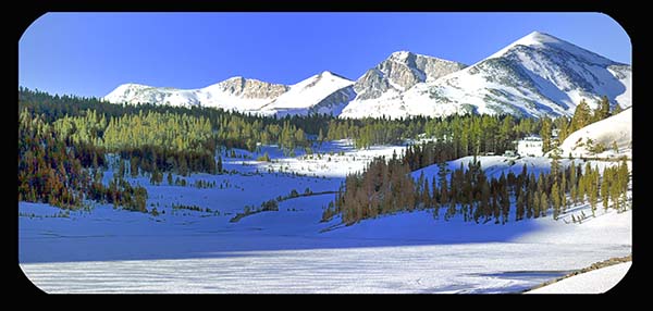
In the image to the left above you can see frozen Ellery Lake (9,489 feet) The Lake is located along the Tioga Road just below the Tioga Pass (9,943 feet)
When the Tioga Pass Road opens varies from year to year (depending on weather and snow conditions). Tioga Pass is the Eastern entrance to Yosemite National Park. It is the highest highway pass in California and in the Sierra Nevada.
WEATHER FORECAST FOR TUOLUMNE MEADOWS AT 8,650 FT
Check out the big temperature drop when comparing the higher elevation of Tuolumne Meadows to the Valley Floor's forecast as noted above.
| Friday 7/26 Sunny, with a high near 68. Southwest wind 5 to 10 mph increasing to 10 to 15 mph in the afternoon. Winds could gust as high as 25 mph. |
| Friday Night 7/26 Mostly clear, with a low around 39. Southwest wind 10 to 15 mph, with gusts as high as 30 mph. |
| Saturday 7/27 Sunny, with a high near 62. West southwest wind 10 to 15 mph, with gusts as high as 30 mph. |
| Saturday Night 7/27 Mostly clear, with a low around 37. West southwest wind 5 to 10 mph becoming light southwest in the evening. Winds could gust as high as 20 mph. |
| Sunday 7/28 Sunny, with a high near 65. Light southwest wind becoming west southwest 5 to 10 mph in the afternoon. Winds could gust as high as 15 mph. |
| Sunday Night 7/28 Mostly clear, with a low around 40. West southwest wind around 5 mph becoming calm in the evening. Winds could gust as high as 15 mph. |
| Monday 7/29 Sunny, with a high near 66. Light west southwest wind increasing to 5 to 10 mph in the morning. Winds could gust as high as 20 mph. |
| Monday Night 7/29 Mostly clear, with a low around 39. West southwest wind 5 to 10 mph becoming light southwest in the evening. Winds could gust as high as 20 mph. |
| Tuesday 7/30 Sunny, with a high near 67. Southwest wind around 5 mph, with gusts as high as 15 mph. |
| Tuesday Night 7/30 Mostly clear, with a low around 43. West southwest wind around 5 mph becoming calm in the evening. |
| Wednesday 7/31 Sunny, with a high near 71. Calm wind becoming west southwest around 5 mph in the afternoon. Winds could gust as high as 15 mph. |
| Wednesday Night 7/31 Mostly clear, with a low around 46. West wind around 5 mph becoming calm in the evening. Winds could gust as high as 15 mph. |
| Thursday 8/1 Sunny, with a high near 72. Calm wind becoming south around 5 mph in the afternoon. Winds could gust as high as 15 mph. |
Above Weather Report Powered by the National Weather Service
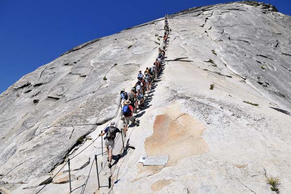
Half Dome Cable Ladder
Psalm 103:11-13
For as high as the heavens are above the earth, so great is his love for those who fear him; as far as the east is from the west, so far has he removed our transgressions from us. As a father has compassion on his children, so the LORD has compassion on those who fear him; for he knows how we are formed, he remembers that we are dust. As for man, his days are like grass, he flourishes like a flower of the field; the wind blows over it and it is gone, and its place remembers it no more.
Email Sign Up

| Join the Adventure! Sign up here for Timberline Trails Monthly Newsletter |

Join us on Instagram
©2006-2023 TimberlineTrails. All Rights Reserved.