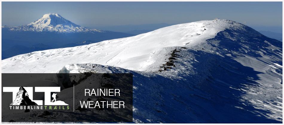
 MT RAINIER pretty much makes it's own weather, and because it stands in the path of prevailing moisture laden marine winds, its southern slopes get some world breaking snow fall, and Paradise Inn (a three story lodge) is frequently buried to the tops of its chimneys in snow. Due to the heavy snowfall on the slopes of Rainier, the mountain sports 26 major glaciers.
 The climbing weather on Mt Rainier is mostly rainy and cold throughout most of the year. This is because the Pacific Ocean produces plenty of moisture. Add to this, the latitude and elevation of the mountain, and you end up with plenty of rain, snow, and frigid conditions that can pop up at anytime of the year.
The best time to climb Mt Rainier is during the months of July and August, when conditions become warmer and drier. But as mentioned above, Rainier makes its own weather and you could find yourself in a white out along with freezing conditions at anytime during the course of the year. So best to get the most current weather report before setting out on any adventure.
 The below information gives you current weather conditions Paradise 5,420 Ft.
| Thursday 7/30 Sunny, with a high near 60. Calm wind becoming west southwest 5 to 9 mph in the morning. |
| Thursday Night 7/30 Mostly clear, with a low around 44. West southwest wind 5 to 8 mph becoming calm in the evening. |
| Friday 7/31 Sunny, with a high near 68. Calm wind becoming west southwest 5 to 8 mph in the afternoon. |
| Friday Night 7/31 Mostly clear, with a low around 47. West wind 5 to 9 mph becoming calm in the evening. |
| Saturday 8/1 A 50 percent chance of rain after 11am. Mostly sunny, with a high near 53. |
| Saturday Night 8/1 A 20 percent chance of rain before 11pm. Partly cloudy, with a low around 37. Breezy. |
| Sunday 8/2 Mostly sunny, with a high near 52. |
| Sunday Night 8/2 Mostly clear, with a low around 38. |
| Monday 8/3 Sunny, with a high near 63. |
| Monday Night 8/3 Mostly clear, with a low around 49. |
| Tuesday 8/4 Sunny, with a high near 70. |
| Tuesday Night 8/4 Mostly clear, with a low around 52. |
| Wednesday 8/5 Sunny, with a high near 69. |
 The below information gives you current weather conditions at Camp Muir 10,080 Ft.
| Thursday 7/30 Sunny, with a high near 46. Light west northwest wind becoming west 5 to 10 mph in the morning. |
| Thursday Night 7/30 Mostly clear, with a low around 37. West wind 5 to 10 mph becoming light. |
| Friday 7/31 Sunny, with a high near 52. Calm wind becoming west 5 to 9 mph in the afternoon. |
| Friday Night 7/31 Mostly clear, with a low around 38. West wind 5 to 10 mph becoming light. |
| Saturday 8/1 A chance of snow after 11am, mixing with rain after 5pm. Mostly sunny, with a high near 42. Breezy. Chance of precipitation is 50%. Little or no snow accumulation expected. |
| Saturday Night 8/1 A slight chance of rain and snow before 8pm, then a slight chance of snow between 8pm and 11pm. Partly cloudy, with a low around 31. Windy. Chance of precipitation is 20%. |
| Sunday 8/2 Mostly sunny, with a high near 39. |
| Sunday Night 8/2 Mostly clear, with a low around 32. |
| Monday 8/3 Sunny, with a high near 49. |
| Monday Night 8/3 Mostly clear, with a low around 42. |
| Tuesday 8/4 Sunny, with a high near 53. |
| Tuesday Night 8/4 Mostly clear, with a low around 45. |
| Wednesday 8/5 Sunny, with a high near 53. |
 The below information gives you current weather conditions at the Summit of Rainier 14,411 Ft.
| Thursday 7/30 Sunny, with a high near 31. West southwest wind 7 to 16 mph, with gusts as high as 21 mph. |
| Thursday Night 7/30 Mostly clear, with a low around 22. West wind 5 to 15 mph, with gusts as high as 22 mph. |
| Friday 7/31 Sunny, with a high near 36. West wind 6 to 14 mph. |
| Friday Night 7/31 Mostly clear, with a low around 23. West wind 6 to 15 mph, with gusts as high as 21 mph. |
| Saturday 8/1 A 50 percent chance of snow after 11am. Mostly sunny, with a high near 27. Windy. New snow accumulation of less than a half inch possible. |
| Saturday Night 8/1 A 20 percent chance of snow before 11pm. Partly cloudy, with a low around 16. Windy. |
| Sunday 8/2 Sunny, with a high near 24. |
| Sunday Night 8/2 Mostly clear, with a low around 17. |
| Monday 8/3 Sunny, with a high near 33. |
| Monday Night 8/3 Mostly clear, with a low around 27. |
| Tuesday 8/4 Sunny, with a high near 37. |
| Tuesday Night 8/4 Mostly clear, with a low around 29. |
| Wednesday 8/5 Sunny, with a high near 37. |
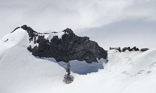
Photo shows North Side of Camp Muir
"Come now, let us reason together," says the Lord. "Though your sins are like scarlet, they shall be as white as snow; though they are red as crimson, they shall be like wool."
Email Sign Up

|
Join the Adventure! Sign up here for Timberline Trails Monthly Newsletter |

Join us on Instagram
©2006-2026 TimberlineTrails. All Rights Reserved.
....