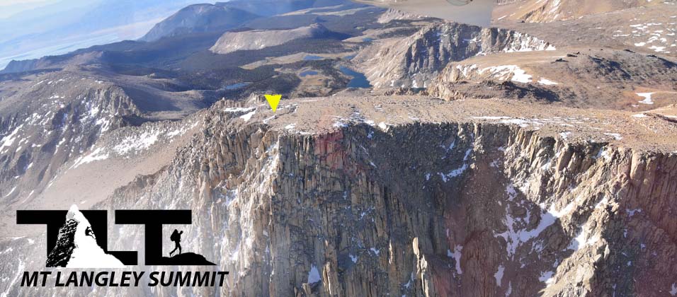
The Summit of Mt Langley - as shown in the aerial photograph above has a commanding view of the Southern Sierra as described below, and is one of the easiest of all the California Fourteener's to climb next to White Mountain which is located on the other side of the Owens Valley about 80 miles to the north.
The Cottonwood Lakes Trail is the easiest way to reach the summit, but for well trained climbers, the north side (as shown in the image above) offers an incredible selection of arete, buttresses, and knife-blade ridges for skilled mountaineers to practice their skills on.
In the center upper portion of the aerial photo above, you can also see many of the Cottonwood Lakes which are located at over 2,000 feet below the summit.
 Mt Langley has a great view of the Southern Sierra Nevada as mentioned above. Here is a small list of peaks that you will be able to see from the summit of Mt Langley. Mt Muir (not shown in the photo
to the left),
above),
Mt Whitney, Mt Russell, Mt Williamson, Middle Palisade, and Split Mountain as well as Mt Langley make up over a third of the California Fourteener's, and they can all be seen from the summit of Mt Langley.
Mt Langley has a great view of the Southern Sierra Nevada as mentioned above. Here is a small list of peaks that you will be able to see from the summit of Mt Langley. Mt Muir (not shown in the photo
to the left),
above),
Mt Whitney, Mt Russell, Mt Williamson, Middle Palisade, and Split Mountain as well as Mt Langley make up over a third of the California Fourteener's, and they can all be seen from the summit of Mt Langley.There is also a great view of the Owens Valley along with the town of Lone Pine. Be careful when approaching the north side of the summit. The drop off is intense, and care must be taken if you want to take a peak down that side of the mountain.
 In the photo
to the right,
above,
you see a view from the summit to the northeast. You can see clear across the Owens Valley below and all the way to 14,246 foot White Mountain nearly 80 miles away. White Mountain is the third highest peak in California.
In the photo
to the right,
above,
you see a view from the summit to the northeast. You can see clear across the Owens Valley below and all the way to 14,246 foot White Mountain nearly 80 miles away. White Mountain is the third highest peak in California.
White Mountain is the easiest 14,000 foot peak in the state to climb. It has a fire road up much of it and a nice large trail up the rest of the way. You also get an even higher start at 11,670 feet verses 10,000 feet on Mount Langley.
Also check out Lone Pine Peak. What seems so imposing from down below in the town of Lone Pine, becomes a gentle slope to the summit as seen from Mt Langley. Lone Pine Peak is 12,944 feet high, so you are looking down 1,098 feet from the summit of Mt Langley. Lone Pine Peak has a trail most of the way, but just like Mount Langley, the last part of the climb involves a class two rock scramble to the summit.
But the scramble up Lone Pine Peak is quite a bit longer than Langley's (about 2,000 ft). To the north (in the photo above), you can see way out to Split Mountain which is another High Sierra 14,000 foot peak. Directly to the east you see Waucoba Mountain which is located in the Inyo Mountains. Waucoba is over 11,000 feet above sea level and is a good example of a desert mountain. Hot and dry.
 In the image to the right, you see Kurt holding the summit register for Mount Langley. Summit Registers are always fun because they let you share your name and experience of climbing the mountain with others.
Summit Registers such as the one shown here, can also be a source of important information when it comes to the history of climbers that assended this or any other mountain that provides a way of documenting peoples experiences.
 In the image
to the left,
above,
you see a great view of Cottonwood Lakes far below. You can even see clear out to Horseshoe Meadows where you began your hike or climb. Also note the position of our campsite on the edge of Lake 3.
In the image
to the left,
above,
you see a great view of Cottonwood Lakes far below. You can even see clear out to Horseshoe Meadows where you began your hike or climb. Also note the position of our campsite on the edge of Lake 3.The photo gives you a super 3D view of the route. You start way back at Horseshoe Meadows as shown in the upper left hand portion of the photo, then work your way along a fairly level section of the trail which eventually turns and climbs up and into the Cottonwood Lakes Basin which is situated at about 11,100 feet. From there you hike up a steep section to gain either the Old Army Pass at an elevation just a bit above 12,150 feet. Then onto the summit which sits at an elevation of 14,042 feet above sea level
 In the photo
to the right
above
you can see Russ and his 13 year old son standing on the summit of Mt Langley. Great accomplishment for all involved, but especially for 13 year old Kevin. It takes a lot of get up and go for young people (or anyone for that matter) to push themselves to achieve a 14,000 foot summit like Mt Langley.
In the photo
to the right
above
you can see Russ and his 13 year old son standing on the summit of Mt Langley. Great accomplishment for all involved, but especially for 13 year old Kevin. It takes a lot of get up and go for young people (or anyone for that matter) to push themselves to achieve a 14,000 foot summit like Mt Langley.I find that fewer and fewer young folks these days are willing to put in the kind of hard work and effort that it takes to summit a mountain like Langley or achieve other difficult goals in life.
Right over the top of Kevin's hat (on the right), you can see Mt Whitney faintly in the background. Mount Whitney (14,496) is the highest peak in the continental United States, and is the goal of many a Mountaineer.
 In the aerial photograph
to the left
above
you see a view from the summit of Mt Langley looking to the west into Sequoia National Park.
In the aerial photograph
to the left
above
you see a view from the summit of Mt Langley looking to the west into Sequoia National Park.The peaks listed below make up a good section of the southern High Sierra, and they also all reside within the boundaries of Sequoia National Park. All except Mt Eisen (12,160 ft) rise above 13,000 feet.
The Great Western Divide (shown in the top right hand portion of the image to the left), above), is a sub-range of the Sierra Nevada in California. It forms part of the border separating Kings Canyon National Park from Sequoia National Park. It separates the watersheds of the Kaweah, Kern and Kings rivers. The Great Western Divide includes the Kings-Kern Divide and the Kaweah Peaks Ridge as you can see.
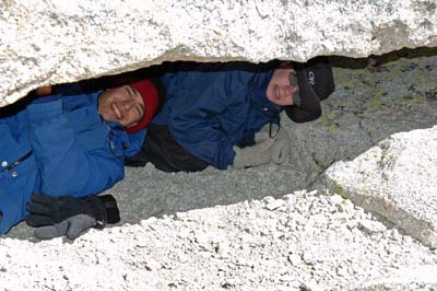 In the image to the right, you can observe Sean (left) and Kevin (right) making good use of a natural shelter on the top of Mt Langley by getting under a small overhanging section of one of the large summit boulders. It was very windy and cold that day on the peak, and getting out of the wind is a big help when it comes to staying warm under these conditions. Natural shelters like these can be lifesavers (if things were to really to get bad). For more information on how to deal with the cold, please visit our page on Hypothermia
Well, that's about it for our page on Mt Langley's Summit. As you have read on this page and others, it is the furthest south of all the fourteen thousand foot peaks in California and sports beautiful 360 degree views from it's wonderful summit.
Email Sign Up

|
Join the Adventure! Sign up here for Timberline Trails Monthly Newsletter |

Join us on Instagram
©2006-2026 TimberlineTrails. All Rights Reserved.
....