 Getting to Mt Whitney via Giant Forest - involves a serious backpack to be sure. It involves a 60 mile trek through mountainous terrain to get the job done. However, looking on the bright side, you will be traveling on great trails that will give you access to incredible beauty. This is the most popular alternate route to Mt Whitney, and it is for serious backpackers only. It requires good planning and all participants need to be in excellent physical condition.
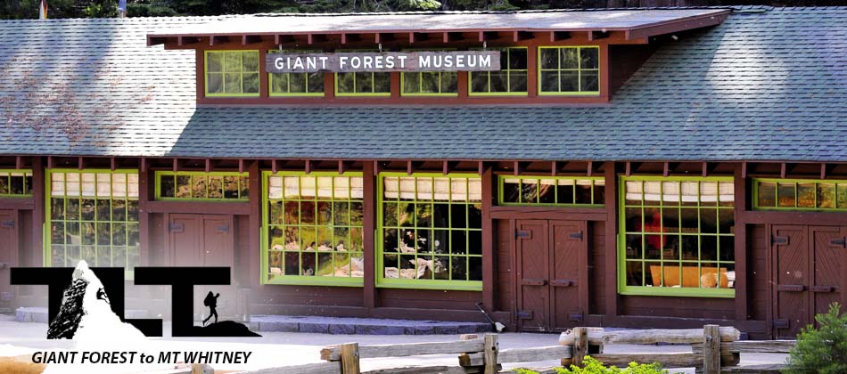
 The trailhead is located in Sequoia National Park near the Giant Forest Museum which you can see in the image above. To get there, just do a quick search on Google Maps, put in your address as your starting point and then put in "Giant Forest Museum, Generals Highway, Three Rivers, CA 93271" as your destination.
You will most likely want to set up a shuttle so that after you hike down the Mt Whitney Trail (to get to the Whitney Portal Trailhead), you can then get a ride to wherever you need to be. Otherwise, you will need to do an out and return adventure (and that would be one long heck of a hike involving about 120 miles or so).
 To begin, you will need a permit and it will be much easier to get than a Mt Whitney Trail Permit. This High Sierra Trail Permit can be obtained at the Lodgepole Visitor Center or you can call them at 559-565-443 and get one set up in advance. After that bit of business is taken care of, you can get started on your adventure.
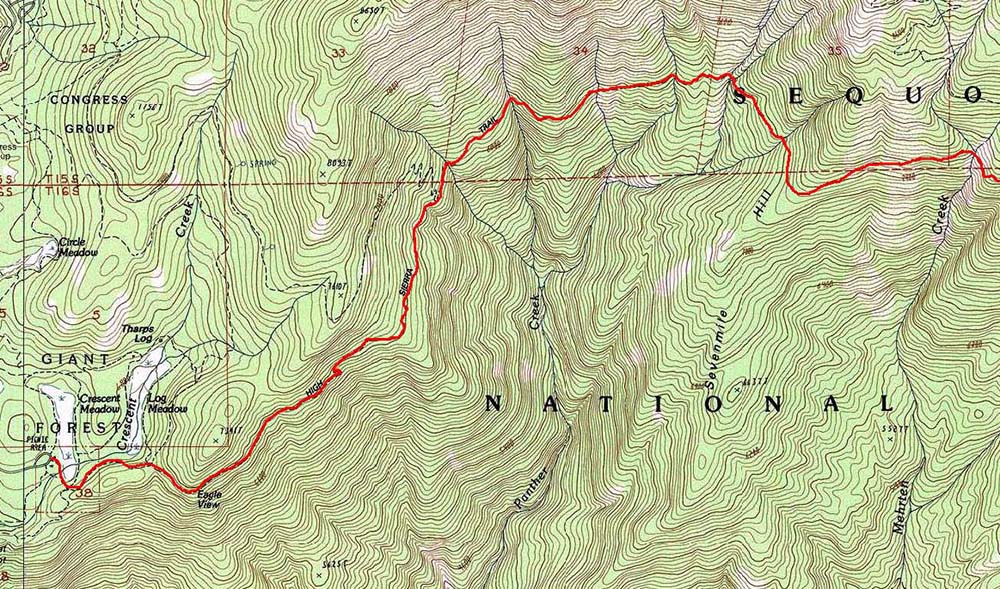
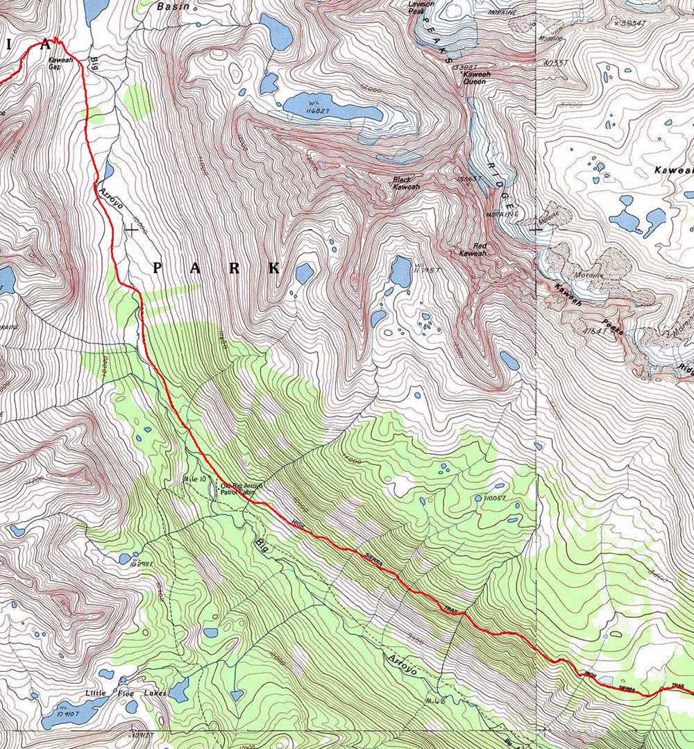
 As seen in the image to the right, you will begin your trek on the High Sierra Trail. The trailhead is located near the "Giant Forest Museum" as mentioned above, and this will mediately take you through beautiful Crescent Meadow. After just one mile of hiking, you will be at Eagle View.
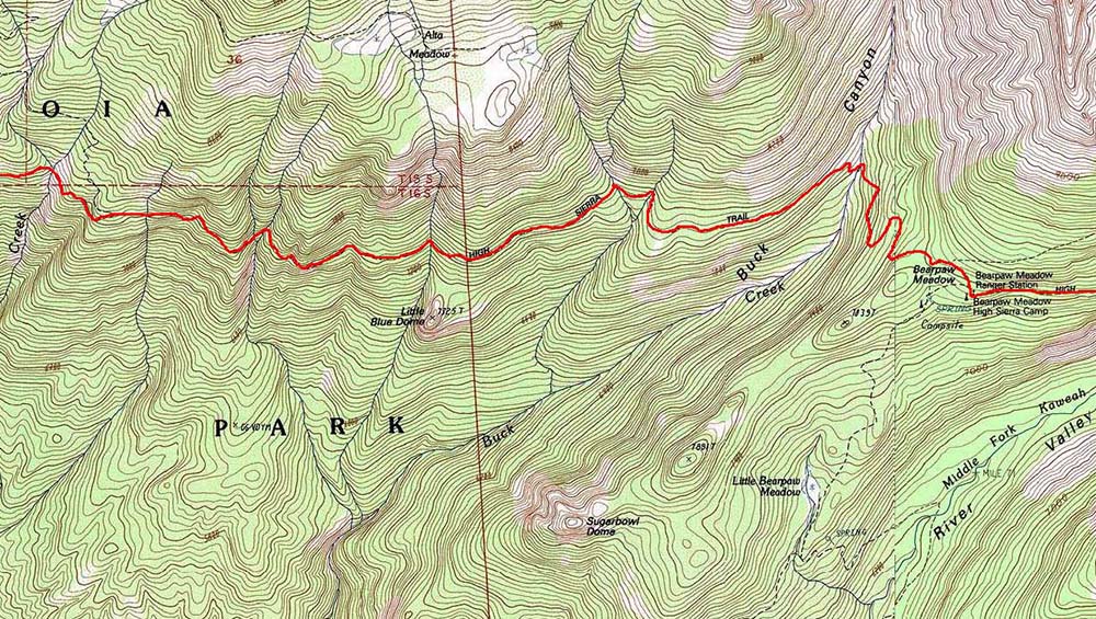
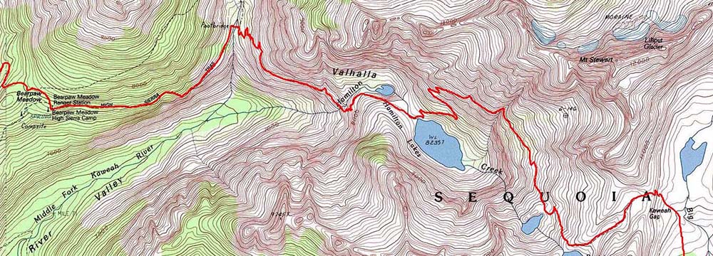
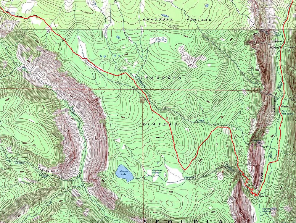
The High Sierra Trail will then take you past Methren Creek and Little Blue Dome. You will be skirting along the 7,000 foot contour line all the way to Bearpaw Meadows which is just a bit past Buck Creek. There is a High Sierra Camp and Ranger Station located at Bearpaw Meadows, and it is a great stopping point for weary travelers. You have now at the 11 mile point, but you have only just begun. Next point of interest is Hamilton Lakes (16 miles from the trailhead) and you will soon be there after crossing a footbridge that takes you over the Middle Fork of the Kaweah River. Next, travel past Precipice Lake, and then climb to Kaweah Gap located at 10,689 feet (21 miles from trailhead). Another 5.2 Miles will lead you to Old Big Arroyo Patrol Cabin. From there you will hike along the Chagoopa Plateau (9,000 to 10,000 foot elevation) to Upper Funston Meadow 14.8 miles further. You are now at about the 40 mile marker from your start.
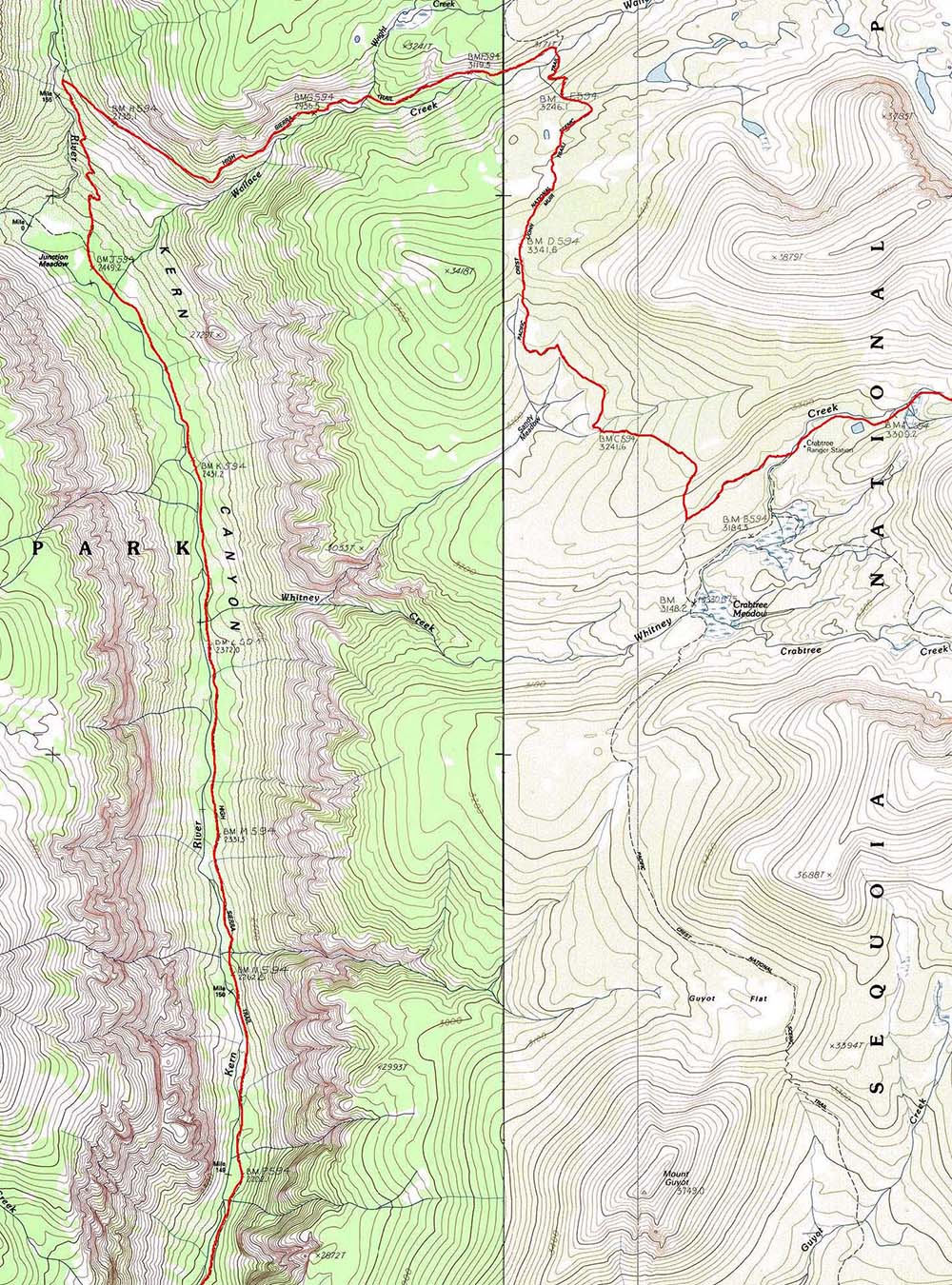
 Proceed another nine miles up the Kern River Valley to Junction Meadow. From there continue about 3.7 miles further where you will join the Pacific Crest Trail. Next stop is Crabtree Meadows where you will find another Ranger Station. You are now at the 52 mile mark. Only 8.5 miles to go to the Summit of Mt Whitney. From Crabtree Meadows you will pick up the John Muir Trail and then pass by Timberline Lake and Guitar Lake. From Guitar Lake (as shown in the right hand middle section of image) work your way up to Trail Crest and then hike across the back side of Mt Whitney for another 2.8 miles to reach the summit (14,505 feet and rising). If you choose the shuttle option, it is another 11 miles to reach the Trailhead of Mt Whitney and the Portal Parking Lot. All in all, once down to the Whitney Trailhead, you will have traveled 71 miles in total. Give yourself a big pat on the back for a job well done!
Below I have included pieces of a GIANT MAP of the entire trail marked in red for you to examine. This way you can see every little detail of the above journey. I overlapped some of the terrain on the right hand side of the top map with the left hand side of the lower map so you could match up the trail. Trail Maps used with permission from National Geographic.
http://www.nationalgeographic.com/maps

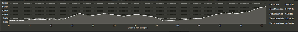 Above is the a graph of the elevation profile of the entire trek. The minimum elevation is 6,702 and the maximum is 14,505 even though it reads 14,474 (I could not get the marker exactly on the summit of Mt Whitney). Doing the math with the exact positions (again, could not get the points exact, but all is within 150 feet accuracy or better), we have a straight line elevation gain of 7,803 feet, but the actual total gain is 20,684 feet do to the fact that we have a 12,881 foot loss that we have to make that up in order to complete the task. So as you can see, this backpacking trek is no joke, and you will certainly have your work cut out for you if you decide to take on the journey. I have not done this particular backpack, but hope to do it someday in the future. From all the photos I've seen along the "High Sierra Trail" I'm sure I won't be disappointed with all the natural beauty I will encounter, and I'm sure you won't either!
Well, thats about it for now. In the future we hope to add much more to this page, but in the meantime please make use of the below link and jump to the top of this page and explore some of our other links on Mt Whitney.
Dave French
Email Sign Up

| Join the Adventure! Sign up here for Timberline Trails Monthly Newsletter |

Join us on Instagram
©2006-2026 TimberlineTrails. All Rights Reserved.
....